
iOS 27 Wireless CarPlay Glitches are a Nightmare
Drivers testing the initial iOS 27 developer beta are warning about severe wireless CarPlay bugs that cause infinite crash loops and broken app menus.
Today Google updated its Google Maps app, along with Street View, to include 130 more cities and towns across Canada.
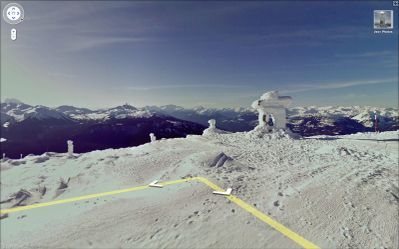
Among the update, Google has brought Street View to the Vancouver 2010 Olympics. The company modified a snowmobile with cameras to capture slope-level images of many areas on the Whistler Blackcomb mountains.
Some of the other Olympic venues include parts of Whistler Mountain, Whistler Village, the Vancouver Athletes’ Village, and Vancouver’s Stanley Park.
The 360-degree, slope-level imagery of Whistler Mountain is the first collected by the newest experimental Street View system, a snowmobile equipped with state-of-the-art photographic and GPS technology. Winter Games fans, skiers and snowboarders around the world can now pan across several Whistler runs as if they were there, and wind through Whistler Village and Whistler Creekside at the bases of Whistler-Blackcomb mountains. Google collected this imagery in partnership with Whistler Resort Municipality and Whistler Blackcomb Mountains.
The new imagery and other tools are being made available on a new Google website that provides information about the Olympic games in 40 languages.
Want to see more of our stories on Google?
P.S. Want to keep this site truly independent? Support us by buying us a beer, treating us to a coffee, or shopping through Amazon here. Links in this post are affiliate links, so we earn a tiny commission at no charge to you. Thanks for supporting independent Canadian media!


This is a good update I hope Apple doesn't try to kill google any time soon
Enhanced maps???!!! I call BS!
There is still no Golden Ears Bridge 8 months after it opened.
I'm in google street view!! One of the locations they added was Cold Lake and I flipped off the car one day when it drove by hahaha
I'm in google street view!! One of the locations they added was Cold Lake and I flipped off the car one day when it drove by hahaha
The slope view is really cool…I’m glad they did it on a nice clear day as well…looks great even on the iPhone!
A gorgeous blog comment,I am very impress with your comment, this comment I will share with my all friends…nice work continue it….