Apple Vans Seen Capturing Street Views, 3D Images for Next-Gen Maps [PIC]
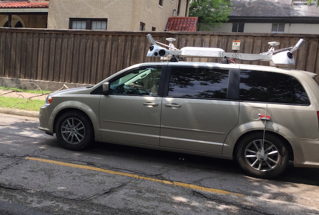
According to a report by 9to5Mac, mysterious sensor-equipped vans found roaming in cities like Los Angeles, Dallas, and New York are apparently gathering data for Apple’s next-gen Maps app, including street view storefronts and 3D images. The report adds that Apple is looking to revamp the foundation of its current Maps application, and is aiming to shift to the in-house base map database by 2017.

Citing unnamed sources, the report also claims that Apple plans to cut off ties with partners such as TomTom by 2018. It is believed that with more control over the core user experience and less need to rely on partners for data to be updated, Apple wants to offer its users more accurate and frequently updated mapping information. The suspected Apple Maps vans are said to be equipped with cameras that are collecting latest Street View data, as Apple is not happy with Street View interfaces developed by Google.
To expand its 3D Flyover mode in Maps, Apple is working on ways to tie together its new camera data to make a street level version of 3D Maps for a future version of its Maps app. As Apple has only recently started collecting its 3D Street View data, such a feature is not likely to be imminent.
Sources say that Apple’s camera equipped vans are taking still pictures of businesses along commercial roads, an initiative Apple has internally codenamed “Project Gardar,” an apparent reference to Norse strongholds in new territory. Apple has planned to begin integrating still exterior photos of points of interest this fall in its iOS 9 Maps app.
Previously, it was reported that Apple is planning to launch a mass-transit directions service for iOS 9, along with new Augmented Reality features for the Maps apps on iPhone and iPad.

