Pathmap iOS and Android Apps Launch to Navigate Toronto’s Underground Network
After launching Pathmap.ca last summer, Toronto creator Eric Rotberg has launched standalone Pathmap iOS and Android apps for download, which debuted last month. The service aimed at making it easier for users of Toronto’s PATH walkway to navigate the complex network of underground tunnels.

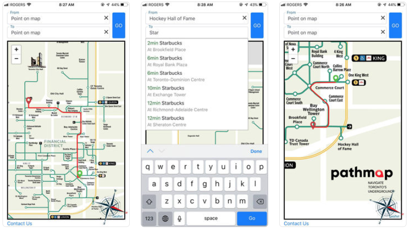
The mobile apps come with new features beyond the original web app release, according to Rotberg. There are new and improved maps which load faster and are easier to read, while there’s a new compass which helps users navigate their orientation and direction, within the underground labyrinth.
Also new are improved search of business names—with suggestions—while the estimation of walking distance is now also included. When users click on a map image, they can now select ‘To’ and ‘From’ to make for quick navigating instructions.
Will the City of Toronto adopt these unofficial maps at all? Nope. Rotberg told iPhone in Canada, funding for the project is their main challenge right now, as “unfortunately the City of Toronto expressed no interest in supporting us.”
As for future improvements planned—depending on available funding—Pathmap will let users add or change businesses and also have a list of ‘favourite places’, plus also improve location services to locate users, plus expand the PATH map to include South of Union Station routes.
The Toronto PATH network is an underground pedestrian network which has 30 kilometres of shops, services and more, used by over 200,000 people daily. But there are no official apps to help navigate PATH from the City of Toronto, yet.
Click here to download Pathmap for iOS and Android—they’re free.

